After a month long break from our last shot at snow, another storm is brewing that could give us the first snow of winter. However, this event will likely be as significant as our last (not very). Heavy rain will be falling all day tomorrow and as it gets colder overnight, wet snow will start to mix in, and the storm could potentially end early Thursday morning as all snow. That said, temperatures will be too high for any significant accumulation, and a dusting, especially on cars and grass, is most likely for Bethesda and Silver Spring. However, our redneck friends up in Damascus and Clarksburg could get an inch or so out of this event, as it will be slightly colder there.
In most snow events, especially those this early in the season, a degree or two can make a big difference, and this storm unfortunately will not be cool enough to create any significant accumulations. No storms seem to be coming up anytime soon, but when the next one does, I'll keep you updated.
Tuesday, December 6, 2011

Friday, October 28, 2011
Snow looking more likely for Saturday
Predicting snow at this time of the year is always a battle between the climatological and meteorological factors. While this storm looks good for snow, and most models are showing a few inches, it's October in D.C. Snow is extremely rare at this time of the year. The models often show storms days out which then disappear or change, and a few days ago, this potential storm was thought to be just that, a random blip that would soon correct itself to fit in with the cimatological norms. However, as we are getting closer to the event, it is becoming more evident that this storm could be the real deal.
Right now I would go with 1-2 inches in most places with maybe 3 up north near Damascus as the most likely scenario. This will be a really heavy and wet snow that doesn't stick to the ground at first and may be mixed in with intermittent rain. As always, the forecast is subject to change change, and could put us in the bullseye, giving us up to 4 inches of snow, or do the opposite, move out to sea, barely giving us anything.
Wednesday, October 26, 2011
Fall Snow?
After our second hottest summer in recorded history, we are finally looking at the possibility of snow. While October would be a remarkably early time to see snow, there is definitely a shot. A storm is riding up the coast taking a track that would guarantee us at least a few inches of snow in a colder month. However, it's October, and snow is incredibly hard to come by, and rightly so. There are more hours of daylight, the ground temperatures are warmer, and the sun is at a higher angle in the sky. For a snow this early, a "perfect" storm is needed.
While precipitation is looking likely for early Saturday morning at this point, the storm will most likely travel too far off the coast, resulting in a cold light rain, possibly mixed in with snow that will melt on contact with the ground. However, the storm could possibly track further inland, creating heavier precipitation that will cool the atmosphere and could result in some minor accumulating snow, possibly up to an inch. However, this snow would not stick for long and quickly melt as it gets hotter during the day. And just as easily, the storm could go out to sea leaving us high and dry.
Even though it would be nice to see some flakes, that's the only redeeming quality about this event that will in all probability just be a miserable and cold rain. If you are really looking forward to snow, this storm is bound to disappoint. Try and wait until December if you want a significant storm and try to enjoy the crisp temperatures of fall while you still can, instead of getting excited over snow.
tl;dr: There is going to be some rain early Saturday morning, snow could possibly be mixed in, but would not accumulate.
Friday, March 25, 2011
Spring Snow?
As unlikely it is for snow to fall this late in the season, we are seeing our first real chance of it for a month, after the high temps since the end of February. However, the chance for a decent snowfall is looking slim. The time the snow would potentially fall would be Saturday night and Sunday morning. At this point, however, the storm looks to be going south, so we will probably be "fringed" and only get the edge of the storm and lower precipitation totals. While a shift north 50-100 miles could lead to a few inches, right now it looks like the snow that falls will be light and melt away quickly. Due to the light snowfall, more intense sun angle, and warm ground; any light snow that falls will likely only stick to grassy surfaces and melt away quickly. Right now, I would call for around an inch grassy areas, and a dusting on the roads.
Tuesday, March 8, 2011
Major Rainstorm Tomorrow
Tomorrow through Thursday, a major rainstorm with likely flooding will impact the area. Starting light Wednesday afternoon, the rain will increase overnight and remain heavy all day Thursday, continuing until the storm tapers off Thursday night. Some minor flooding is definitely possible, as the ground is saturated from this weekend's storm. We will likely get 2-3 inches of rain, and unlike the weekend storm, it probably will not change to snow at the end. Try to enjoy the miserable rain and forget that it would of been 20-35 inches of snow.
Monday, February 28, 2011
Thunderstorms Today
Although snow is unlikely for the rest of the year, I'll still post updates on extreme weather. Today, there is a fairly high chance of thunderstorms in the afternoon that could be severe. It will be windy and intense, but not bad enough to cause mass blackouts. Thunderstorms are hard to really predict in the future, as they are fairly spontaneous, but the environmental conditions suggest they are very likely, but its possible that you will get just clouds while a friend 10 miles from you is getting heavy hail. That said, be ready for a shift from snowstorms to thunderstorms.
Monday, February 21, 2011
Snow On Track For Tonight 10 PM Update
 Sleet is spreading across the region now and the precipitation is moving south. My forecast totals aren't changing, and 4-8 inches is still likely. In the next hour or so, sleet will change to snow from the north and the snow will continue overnight. The snow will taper off in the morning hours and it will be very cold tomorrow and tomorrow night. Schools will most likely be closed tomorrow, so but set your alarm early just in case! The official odds are 85% chance of closure with 15 % chance of delay.
Significant Snow to Arrive Tonight

A storm is currently forming in the Midwest and will affect the area tonight. It will likely start as a light drizzle and turn to sleet quickly. Then at around 11 pm, it will turn to all snow, earlier as you go north. The snow will continue overnight, heavy at times, until it tapers off in the morning. The totals will range from 4-8 inches throughout the county, with the higher amounts north near Damascus. There is currently a Winter Storm Waring, and due to the perfect timing at night, school is very unlikely. I'd say MCPS has a 85% chance of closure and a 15% chance of a delay. Since this is going to be a major event, I'll post a later update at around 11 o'clock.
Sunday, February 20, 2011
Moderate Snow Likely Monday Night

After waffling all day yesterday, the models have seem to come to a consensus on the storm, and that consensus suggests a sizable snowfall. While not as intense as our storm about a month ago, this storm could still have a significant impact, as it will happen overnight until rush hour. Even though highs could get to the mid 50's tomorrow, temps will plummet as the precipitation arrives, so the storm will start as light rain, transfer to sleet and finally to snow for most of the precipitation. While it is still a while away, so things could change, it is unlikely that this will be a total bust. In Montgomery county, I'd expect 3-5 inches with more towards Damascus and less near Chevy Chase. Schools could be closed due to the timing of the storm, so stay tuned for more info.
Thursday, February 17, 2011
Chance of Snow Monday/Tuesday?
Enjoy the great weather while it lasts as we might have another snowstorm next week! Details are hazy as it is still 5 days out but it is likely a storm will track near us and temps will be cold enough for at least a changeover to snow. Some models show up to 10 inches while others show only an inch so anything could still happen. Enjoy these 70 degree days but remember it's the middle of February so there is still a chance for snow. As the event gets closer, I will post more updates so stay tuned!

GFS for Tuesday morning, showing a major snowstorm
Wednesday, February 9, 2011
Update: Light Snow to Continue Overnight
Currently, the radar is intensifying around us and most people already have a dusting. This extremely light snow could briefly become a bit heavier, as a light-moderate band comes through until 11. While it still won't be anything significant, we could eke out an inch overnight. School odds: 24.9% chance of a delay, .1% chance of closure, and 75% chance of a normal school day.
Snow Tonight Looking More Likely, Still Minor

The precipitation over the central US is currently stronger than anticipated and further north too. While this storm dropped over a foot on parts of Arkansas, it will be weaker once it arrives here, and will only skirt us. The air will be very cold, so any snow that falls will be light and fluffy, unlike the wet snow that we got earlier this year. In addition, we have very dry air, so some snow that shows on the radar may just evaporate in midair. While our chance for a dusting has increased, it's still extremely unlikely that we will get enough snow for even a delay. If anything changes, for better or worse, I will post an update tonight.
Tuesday, February 8, 2011
Snow Possible Tomorrow Night, Flurries or a Dusting At Most
Wednesday Night Forecast
So, the models have trended somewhat north, which is good for our snow chances. Also, the low pressure in Texas is stronger than anticipated which is good. However, despite these improvements, accumulating snow is still extremely unlikely. My odds are 50% chance of nothing, 25% chance of flurries, 20% chance of dusting, and 5% chance of 1/2 inch+. As you can see this storm doesn't really have much potential, but a nuisance dusting could await us Thursday morning.
Long Range Forecast
From Thursday to Saturday we will have some cold weather, with lows going down to the teens and highs in the low to mid 30's. Next week will start with some warmer air, possibly reaching 50 degrees. After tomorrow night, there are no snowfall possibilities in the next week, but it could get colder towards the end of the month, and since it's early February, we still have a chance of at least a snowstorm or two to track later in the month.
Monday, February 7, 2011
Storm Tonight Looking Extremely Minor, Thursday Storm on Life Support

Tonight, we could see a little snow or rain, but either way it will be a non-event.
Thursday things get a little more interesting with a storm coming up the Atlantic coast. However, as of now, accumulating snow is unlikely as it seems the storm is going to go out to sea. Since that's still 3 days away though, there is a chance, albeit small, that this storm could shift north. But right now, it looks as if it will just be flurries.
The storm going out to sea, as predicted by the most recent GFS forecasting model.
Image Source: Capitalweathergang and Raleigh Weather.
Sunday, February 6, 2011
Never Forget
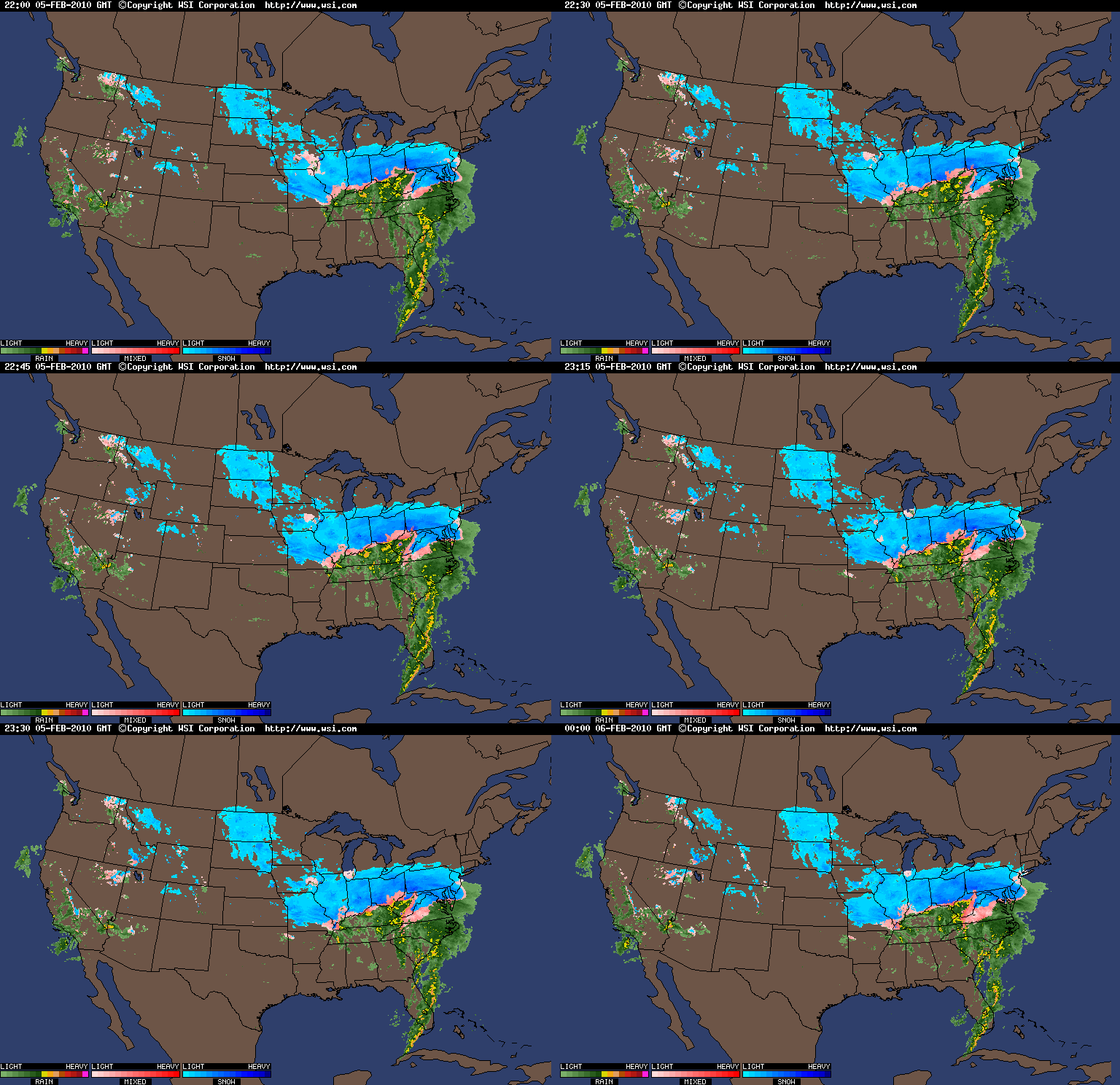
At this time last year, Snowmageddon was winding down. Here's an epic radar to help relive it. 
Two Storms to Follow
Next week 2 storms are coming. One will likely happen Monday night and one around Thursday. Right now, the temperature looks to be too high for any decent snowfall Monday night. Yesterday, a few models were showing a potentially significant storm for Thursday. However, it looks more likely that the storm will just go out to sea at this point. However, since it is still 4 days away, a lot could change, so don't give up on it yet.
Subscribe to:
Posts (Atom)